Why does Yemen succeed in shooting down aircraft when this has proven more difficult for Iran Lebanon and Syria
CosmoTrade | تجارة الكون @Cosmos_politic
Translated
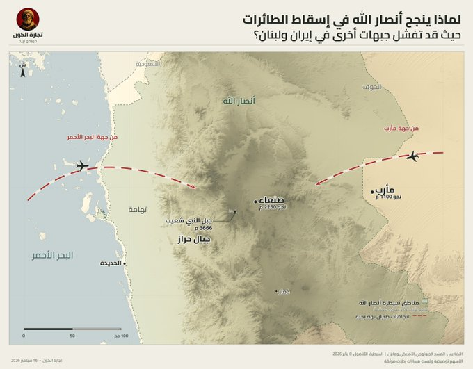
Why does Yemen succeed in shooting down aircraft when this has proven more difficult for Iran, Lebanon, and Syria? And why is flying over Yemen extremely difficult even for the most advanced fighter jets? Geography is the reason. Today, Ansar Allah announced the downing of an advanced Saudi F-15 fighter over Marib, and they released footage of the moment it was targeted and of its wreckage. This comes as part of a long record for Yemeni air defense, which has shot down large numbers of American drones, chief among them the MQ-9, and has succeeded more than once in threatening American and Saudi fighter jets and forcing them to maneuver and withdraw. But why do the Yemenis succeed in this with such limited tools? The answer begins with geography. The heart of Ansar Allah's control areas lies in the midst of one of the most complex mountainous environments in the region: mountains exceeding 3,000 meters, deep valleys, high plateaus, and enormous elevation breaks over very short distances. These are not just challenging terrains for ground forces; they are a real problem for radars and aircraft as well. Take Sana'a, for example. Sana'a itself sits at an elevation exceeding 2,200 meters, and directly to its west rise the Haraz Mountains, while nearby the capital, Jabal al-Nabi Shu'ayb reaches 3,666 meters, making it the highest peak in the Arabian Peninsula. Any aircraft wanting to reach Sana'a from the Red Sea side practically starts from the low-lying Tihama region and then faces ahead of it a wall of elevations rising to more than 2,000 and 3,000 meters before arriving at the Sana'a basin. That means it doesn't approach a target situated in the midst of open terrain; it has to deal with a full chain of mountains, peaks, and valleys that continuously interrupt the radar line of sight. Radar can't see through a mountain. Every mountain creates a radar shadow zone behind it, and every valley can hide a radar, a launcher, or an observation team. The aircraft emerges from behind one mountain mass and then disappears behind another, while air defense can remain concealed until the moment the aircraft enters the engagement window. And take Marib, where the F-15 was shot down, as a second example. Marib sits at an elevation of around 1,100 to 1,200 meters, but the terrain rises rapidly toward the western highlands and Sana'a to more than 2,000 meters. Any aircraft operating over Marib and then approaching the heart of the Yemeni highlands transitions from a lower basin into a network of mountain ridges, plateaus, and valleys. And for this reason, there isn't a single exposed geographical surface in front of the radar, but rather terrain that interrupts visibility and continuously creates areas it cannot monitor in a connected manner. And here, geography itself becomes part of air defense. Ansar Allah has also built their defense operations in a way that suits this terrain. Instead of relying solely on large radars that operate continuously and reveal their position, they use a combination of radars, visual observers, electro-optical and thermal sensors, and passive detection means, then activate engagement systems at the appropriate moment. The Americans have tested this themselves. In March 2025, American F-16 fighters over Yemen fell victim to a missile ambush in which they received no warning until about 15 to 20 seconds before the missiles arrived. And after the campaign, American officials said they couldn't fully understand the Yemeni air defense network, because Ansar Allah combined radar with visual observation, thermal and electro-optical sensors that don't appear the same way on radar warning devices. And during the campaign itself, American aircraft fired around 50 HARM anti-radar missiles in about twenty engagements with Yemeni air defenses. And this is the key point. Iran possesses much heavier and more advanced air defense systems on paper, and Syria had a large network of batteries, and southern Lebanon is mountainous too. But in Yemen, three things converge in one place: towering and interlocking mountains, mobile and concealed air defense, and passive detection means that don't require running the radar all the time. And that's why the pilot over Yemen doesn't face just a missile. He faces the missile and the mountain and the valley and the elevation and the radar shadow and the ambush all at once. That's why a relatively limited air defense system can become far more dangerous amid Yemen's mountains than its paper capabilities suggest. In Yemen, geography itself fights alongside air defense.